
Every year at the Esri Safety & Security Summit, I sit across from emergency managers, transportation directors, law enforcement leaders, and GIS professionals who are all trying to solve a version of the same problem: how do we know what’s happening, right now, in the places we’re responsible for protecting?
This year, that question carries more weight. The threat environment facing state and local governments has widened. Infrastructure is a target and events are moving faster than response plans were built to handle. Further, the tools most organizations are working with (legacy alerting systems, manual information-sharing processes, phone trees) were not designed for the modern landscape.
When my team heads to this year’s conference, three themes are going to drive every conversation we have: resilience, modernization, and real-time information. Here’s what those mean in practice.
Resilience as a Capability
When government leaders talk about resilience, they often mean the ability to recover after something goes wrong. That framing is too late.
Real resilience — the kind that protects buildings, infrastructure, and citizens — is built on the ability to act before an event escalates. That kind of resilience requires information from the earliest possible moment and ongoing throughout the event. Not information that arrives after a 911 call. Not a news alert from a reporter who got there first. Information that reaches decision-makers at the moment something starts to unfold.
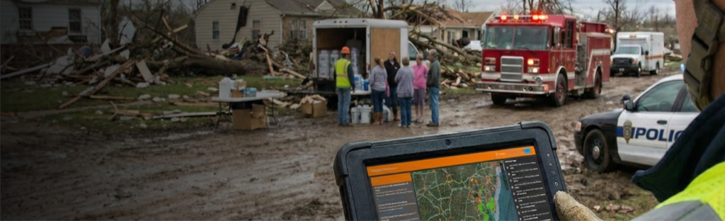
This is where Dataminr First Alert changes the equation for Esri ArcGIS users. By continuously processing over 1.5 million public data sources (social media, news, sensors, deep and dark web, and more), First Alert surfaces real-time intelligence about emerging events, threats, and risks that can be integrated directly into existing Esri maps, dashboards, and apps. Decision-makers aren’t switching between screens or waiting for a briefing. They’re seeing what’s happening, in geographic context, inside the environment they already work in.
The result: more proactive resilience-building steps to protect infrastructure, enable faster decisions, and empower leaders who are ahead of events rather than behind them.
Modernization Means Bringing AI Into the Environments You Already Use
There’s a conversation I’ve been having more frequently with SLED customers, and it goes something like this: “We use Esri. We trust Esri. How do we make it smarter?”
The answer is straightforward. Dataminr is an AI company that has been building and deploying proprietary AI models since 2019. Our platform currently runs 60+ purpose-built LLMs, developed in-house, and trained on over 13 years of event, threat, and risk data. That unmatched AI capability can now be embedded directly into the Esri ArcGIS environment through a custom connector we built specifically for this purpose.
What does that mean practically? A county emergency operations center doesn’t need a new platform to operate real-time automated workflows. A state transportation department doesn’t need to hire additional staff. The intelligence flows into the tools they already use — giving them access to AI-powered, real-time event detection without adding complexity to their operations.
For airports, transportation agencies, and government facilities managing executive protection or perimeter security, the scope of what’s now available in the ArcGIS environment is meaningfully different from what was possible two or three years ago. The speed and depth of information has changed. And the ability to use that data to power more sophisticated analytics — digital twins, event modeling, tabletop planning — has expanded as a result.
Getting started is not a large lift. Once an organization makes the decision to integrate real-time intelligence into their ArcGIS environment, the connector can be operational in a matter of days.
Democratizing Real-Time Information for a Common Operating Picture
Early awareness is a critical advantage. Equally important is completeness of information and the speed at which that complete picture reaches everyone who needs it simultaneously.
Most of the information-sharing failures I’ve seen in state and local government are a result of siloed systems and legacy communication chains. Today, when an emergency happens, the chain of communication might look something like this: An event happens. One department finds out first. They call another some time after performing their department’s due diligence. That department calls another. Each subsequent department only engages their response protocol once they have found out about the incident. By the time the relevant stakeholders have a shared picture of what’s happening, the window for a proactive response has already closed.
What Dataminr enables, inside the Esri environment, is a common operating picture. This is a live, shared intelligence layer that allows transportation directors, law enforcement, emergency managers, and public communications teams to operate from the same information, at the same time, without waiting for a phone call.
The practical impact is visible in situations where minutes matter. When a critical infrastructure disruption occurs (e.g. a rail incident, a utility event, a weather-driven emergency), the organizations that respond most effectively are the ones whose stakeholders already know what’s happening. Rather than reacting, they’re executing a response to a situation they understood before it escalated.
Visualizing that information within the context of your geography and your specific infrastructure is what transforms an alert into an actionable intelligence product.
Questions We Hear Most Often
How do I get Dataminr AI and real-time data into my Esri environment?
Through a custom Dataminr-Esri connector we built specifically for ArcGIS integration. It connects our AI platform to your Esri environment directly with no major infrastructure changes required. Additionally, as of June 2026, Dataminr First Alert intelligence can also be integrated through ArcGIS Velocity for ArcGIS Enterprise and ArcGIS Online by way of a native Velocity connector for organizations that are using Esri’s real-time data ingestion and analytics engine.
How long does it take to stand up?
Once an organization decides to move forward, we can typically have the feed operational within days. This is not a months-long implementation.
Who is already using this?
Dataminr First Alert is trusted by more than 100 U.S. government agencies. The Esri connector is currently in use by organizations across the country, spanning transportation, emergency management, and public safety.
See You at the Summit
If you’re attending the Esri Safety & Security Summit, come find our team at our booth or book a meeting with us using this link. The conversations I have at events like this directly shape how we build and deploy Dataminr — and the problems you’re working on are exactly the ones we’re built to address.
If you won’t be there but want to understand how the Dataminr-Esri connector works for your organization, ask your Esri representative about the Dataminr integration or visit dataminr.com to get in touch.
Elevate Situational Awareness with Geographic Context
Learn how Dataminr and Esri provide AI-powered real-time event, threat, and risk intelligence within the world’s leading spatial analytics platform. Make faster, data-driven decisions to protect people and infrastructure.
Learn more